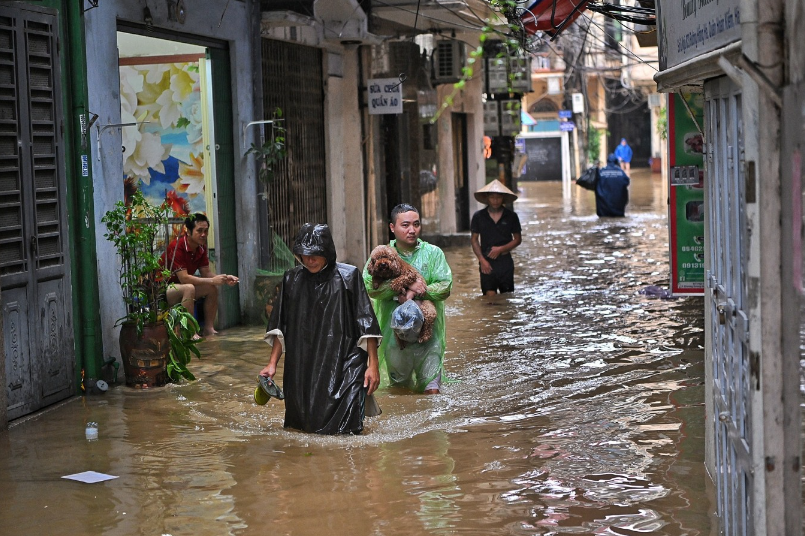
Climate change is amplifying the effects of La Niña, resulting in more intense storms, severe flooding and prolonged extreme weather conditions, experts said, warning of increasingly unpredictable natural disasters.
Le Thi Xuan Lan, a former deputy head of forecasting at the Southern Region Hydro-Meteorological Center, said typhoon Yagi occurred during the transition from ENSO (neutral) to La Niña (cooling sea surface temperatures), which began in September.
But she emphasized that this transition is not the reason for the storm’s intensity and subsequent flooding that has ravaged many northern provinces since Yagi made landfall on Sept. 7.

The primary cause is climate change, which is causing La Niña to exhibit anomalous characteristics, leading to stronger and more frequent storms occurrences and prolonged heavy rains, floods and landslides, she said.
She explained that these anomalous characteristics of La Niña are due to climate change-induced atmospheric warming, commonly referred to as global warming, which increases sea temperatures.
Even a 0.5-degree Celsius increase in sea temperature is enough to provide the energy necessary for stronger storms, she said.
The warming atmosphere also alters circulation patterns, making air masses more active or deviate from typical climatic norms, leading to extreme weather events, she said.
Typhoon Yagi entered Vietnamese waters on Sept. 3 and intensified into a super typhoon two days later, with sustained strong winds reaching 201 kph.
It made landfall over the northern coast with winds of up to 149 kph.
The most powerful storm in Asia this year, it is the strongest to hit Vietnam in three decades.
By Tuesday, the death toll due to landslides, flash floods and fallen trees due to the storm has reached 292, with 38 others people missing.
Professor Phan Van Tan, an expert in hydrometeorology and climate change at the University of Science, Vietnam National University, Hanoi, highlighted that the transition from El Niño to La Niña complicates weather patterns as evidenced by typhoon Yagi.
“The appearance of a storm at this time is not unusual, but the strength of the storm is. Climate change is disrupting many natural laws.”
Late August to early September is when sea temperatures are warmer than other months, providing favorable conditions for storms to develop rapidly, he said.
Lan said factors such as high sea surface temperatures, the storm’s slow movement and the accumulation of energy in warm waters with moderate wind shear contributed to the storm’s rapid intensification into a super typhoon.
She said forecasts for El Niño and La Niña are made by global meteorological centers (Vietnam does not yet have such forecasts), who predict the likelihood and timing of these phenomena on a monthly basis for up to nine months in advance.
Current forecasts indicate that the La Niña phase has begun and is expected to last until at least next spring.
La Niña years typically have more storms than El Niño years because the convection system in the western region pushes closer to Vietnam, leading not only to more storms but also to heavier rainfall.
The forecast suggests that the average monthly rainfall from now until the end of the year will be at least 10-20% higher than normal.
Model forecasts indicate that at least two storms (or tropical depressions or disturbances) are likely over the East Sea in September, with central and north-central Vietnam bearing their brunt.
Lan advised people to follow weather forecasts, particularly about abnormal phenomena such as storms, tropical depressions, heavy rains, and cold spells, to respond promptly.
She predicted that during the peak storm season from September to November there could be two to three storms a month.
Storms and floods could continue until early 2025, mainly affecting the northern and central regions though the south-central and southern regions could be directly impacted by at least one storm at year-end.
The northern region’s terrain, with its mountains, steep slopes, wide and long rivers, and numerous hydropower dams, makes for complex flood situations, especially flash floods and mudslides, which pose a threat to people.
To mitigate the impact of natural disasters, she reiterated the importance of conserving forests to reduce the impact of upstream floods.
“If forest areas continue to shrink, natural disasters caused by climate change will become increasingly severe.”
La Niña and El Niño are two extremes of a recurring climate pattern that can affect weather worldwide.
La Niña occurs when temperatures in the eastern Pacific Ocean along the western equatorial region of South America cool by at least half a degree Celsius compared to normal.
In contrast, this area warms up during El Niño.
While these temperature fluctuations seem minor, they can have significant effects on the atmosphere, creating a ripple effect across the planet.
Since June 2023, when El Niño set in, new temperature records were set for 10 consecutive months across the globe.
While La Niña may help cool temperatures, greenhouse gases contributing to global warming are still increasing.
Although the transition between El Niño and La Niña can cause short-term temperature fluctuations, the overall trend is that Earth is getting warmer.
According to U.S. website Live Science, due to the upcoming La Niña phenomenon and current extremely warm Atlantic surface temperatures, the tropical climate and weather research group at Colorado State University predicts a very strong Atlantic hurricane season, estimating 23 storms (well above the average of 14.4) and five Category 3 (wind speeds of 179-209 kph) or higher hurricanes.
This year could be similar to 2010 and 2020, both of which saw active hurricane seasons, though it remains uncertain whether the powerful storms will impact land.
Article Credit: e.vnexpress